
Here are some tidbits of Adirondacks News that I have stumbled across in the past few days...
Appellate Court Upholds Paddling Rights
from adirondackalmanack.com
 |
| Photo Credit: adirondackalmanack.com |
The subject touches on an aspect of the Adirondack park that I raised in my blog entry last week. As I mentioned then, just a little more than 50% of the Adirondack Park is in in private hands. Those who do own land here are subject to the most restrictive development regulations anywhere in New York State.
The subject of the article, Phil Brown, first caught my attention when I read one of his articles in a magazine at White Pine Camp titled "Osgood as it gets." It traces a canoe journey from Jones Pond (where my childhood summer camp Adirondack Swim and Trip Camp "ASTC" is located) to Osgood pond and finally up the Osgood river. Not only is "Osgood as it gets" a nice piece of writing, but it also bridges two special places to me, ASTC and White Pine Camp. I have mentioned Phil Brown (or used the map from his article) in previous blog entries, here, here and here.
(Please note: the link to the article "Osgood as it gets" can only be accessed if you create an account on Adirondack Explorer, but this can done quickly and without divulging any sensitive information.)
APA Approves Controversial Subdivision
from adirondackalmanack.com
 |
| Photo Credit: adirondackalmanack.com |
Phil Brown is the author of this article instead of it's subject. You see, the Adirondacks is essentially a village.
In my most recent blog entry, I discussed about how development in the Adirondacks is regulated by the Adirondack Park Agency (APA), and there is a constant struggle between maintaining this place as a wildlife refuge and developing parts of the park for private residence, commerce or for recreation. The battle often pits economic viability against environmental conservation. I would add, this debate also pits rich people against poor people. If you look at the development plan I inserted above, it is significant to note that the subdivided parcels range in size between 3 and 145 acres - and the majority of these are on the larger end of that scale. The article mentioned that this development will generate $60,000 in new tax revenue per year. That means the largest parcel will be paying over $2400 in taxes each year. Or, to put it on another scale, the largest property is more than four times the size of White Pine Camp. By any account, the housing going in here is well out of line with the typical income of the park's year round residents. I am reminded of the era of the "great camp" where Vanderbilts, the Rockefellers, the Carnegies, et. al. staked their claim to this precious space.
Hiking Mount Jo near Lake Placid during winter’s coldest week
from ottawaroadtrips.com
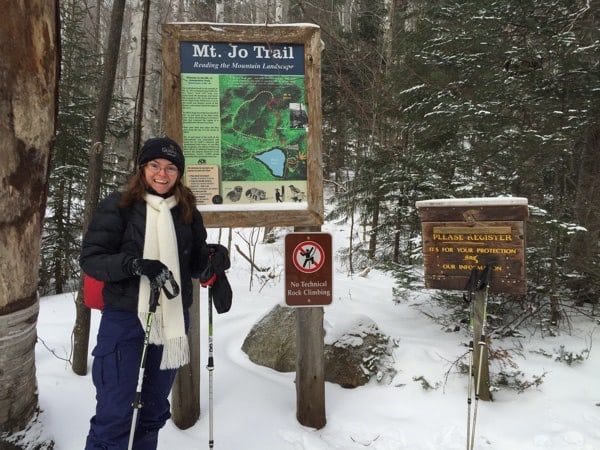 |
| Photo Credit ottawaroadtrips.com |
As I have mentioned before, Mt. Jo, was the first mountain that I climbed in the Adirondacks. On our most recent jaunt up little Mt. Jo, our journey actually continued from there to Ottawa, the starting point perspective of this article. There are two significant differences between our experience an the one mentioned in the article: we made it to the top, and we weren't subjected to -26°C temperatures. In fact, I have never experienced the park in these conditions. One aspect of the article did make me cringe though: "due to my schedule, we only had about an hour," the author writes. Accordingly, the story only takes us part way up this mini-mountain! The lakeplacid.com website describes Mt. Jo as taking two hours round trip for the experienced hiker and 2 1/4 for the "out of shape hiker." Seriously, who travels 250 km from Ottawa to write an outdoor adventure piece about the Adirondacks and doesn't allow for more than an hour on the trail?
An old favorite in winter
from adirondackexplorer.org
 |
| Photo Credit: adirondackexplorer.org |
Who Rules the World?
Podcast by Ed Kanze on mountainlake.org
Well, the connection to the Adirondacks in this podcast is perhaps tenuous, but it is from Ed Kanze, so I decided to include it here. In this podcast, Ed ponders whether girls rule the world. At the end of it, he mentions his new book "Adirondack Life and Wildlife in the Wild Wild East," which I just finished reading and warmly recommend. He also mentions a series of videos about the Adirondacks which have since been completed, you can find links to these at this previous blog entry. As Ed typically gives a weekly nature walk at White Pine Camp during the months of July and August, we look forward to meeting him then!
No comments:
Post a Comment